Showing posts with label County. Show all posts

Friday, 18 November 2011

Old Maps of Oxfordshire

The county of Oxfordshire and the city of Oxford are well recorded by the map makers of the 18th and 19th century.  Variations in style by the cartographers, engravers and artists enrich the depiction of old maps of old maps of Oxfordshire.

Robert Morden's old map of Oxfordshire was initially produced in the latter part of the 17th century and appeared in a number of subsequent 18th century editions.  It has a pleasing clarity and  a characteristic decorative title cartouche.


Old map of Oxfordshire by Robert Morden circa 1753

Another 100 years on and print making was revolutionised by the introduction of mild steel which replaced the much more expensive copper as a material for engraving.  This is illustrated in the old map of Oxfordshire by Archibald Fullarton.  A much smaller map than that of Robert Morden, iit benefits from the fine lines and detail of steel plate engraving and includes an attractive vignette of the city of Oxford.


19th century old map of Oxfordshire by Archibald Fullarton

Shortly after Fullarton produced his maps, Thomas Moule produced the last decorative atlas depicting the English Counties.  Moule was especially interested on heraldry, and consequently his county maps were decorated with many of the relevant coats of arms relating to each county and their prominent families.  Moule's maps were mainly produced by two engravers, John Dower and W. Schmollenger.


19th century map of Oxfordshire by Moule dated circa 1850

 Thomas Moule's Maps were included in many publication,s including Moule's English County Maps and Barclay's English Dictionary. Not only did these beautiful maps benefit from the introduction of  heraldic elements, the engravers embellished them with highly decorative borders and related topographical vignettes.


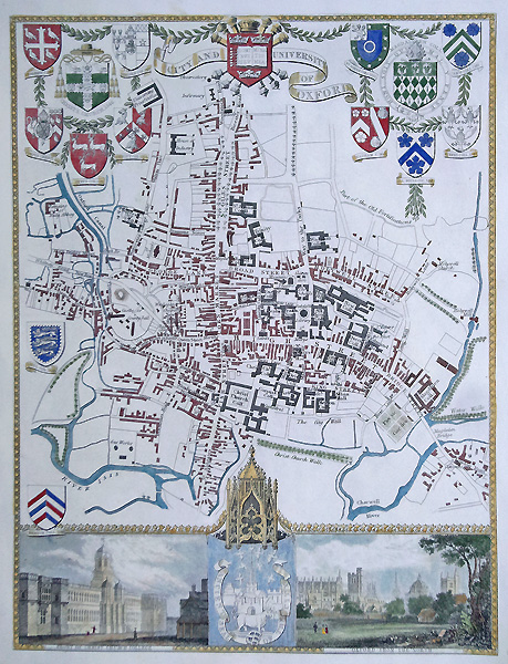
Original 19th century old city map of Oxford by Moule c.1850


Within each publication was also a  selection of antique city maps and old town plans. These plans benefited from even more heraldic content as well as detailed street plans with significant buildings also annotated.  A good example of this is the old map of Oxford by Moule, with no fewer than 15 coats of arms ant two vignettes of Oxford.


See all our antiquarian maps online here

Website design in Devon by Alphawebsites

Looking for affordable gifts for the home? Tealight Wall Holders | Silver Champagne Bucket | Decorative Candle Stands

Friday, 17 September 2010

Original Antique Map of Surrey by John Speed


Published by Basset and Chiswell circa 1676, before the top left corner of the copper plate became damaged. Full details here - John Speed Surrey Map


John Speed (1552-1629)


Born at Farndon in Cheshire and followed his father's trade as a tailor. By 1584 he had moved to London with his wife (Susanna who bore twelve sons and six daughters) and been made a Freeman of Merchant Tailors in 1580.

He was a keen amateur historian and map maker, producing maps for the Merchant Tailors in 1598. Became a member of the Society of Antiquaries where it is likely that he came into contact with leading historians of the day such as Sir Robert Cotton, William Camden, whose text he had read, and perhaps even Christopher Saxton. His interests came to the notice Sir Fulke Greville who made an allowance so that he should be free to write a history of England and, by courtesy of Queen Elizabeth, he worked from a room in the Custom House.

A good historian, he was a great gatherer of information 'I have put my sickle to other men's corne'. Most of his map material was copied from Saxton: however, John Norden (c.1548-1625)) and William Smith (c.1550-1618) had produced maps of some countries and Gerard Mercator maps of the regions. Yet Speed must have travelled extensively, for his maps go well beyond those of his predecessors. By including the hundreds, the inset town plans and heraldic devices of his maps and modifying the Camden text in the atlas he assured its success and lasting appeal.

Useful links:

John Speed antique maps

Antique Prints website - fully searchable catalogue

Extensive online catalogue of antique maps

Collect antique paintings and pictures

Interior Home Accessories - ornaments and contemporary furniture - a blog for Interior Designers, Decorators, Architect and Property Developers

Wednesday, 7 July 2010

Antique Map of Cambridgeshire

19th century antique map of Cambridgeshire 


Antique Map of Cambridgeshire from Moule's English Counties dated circa 185.  Features county heraldry and a vignette of Wimpole.

Full details here: Antique map of Cambridgeshire by Thomas Moule

Condition: Paper good, close top margin, later hand colouring.

Other antique maps by Thomas Moule

Antique maps of Cambridgeshire

Browse our extensive catalogue of antique maps here

Monday, 23 November 2009

Eighteenth century map of Sussex by Emanuel Bowen

[caption id="attachment_98" align="alignnone" width="497" caption="Original Antique Map of Sussex by Emanuel Bowen"][/caption]

From the Large English Atlas by Emanuel Bowen circa 1760. Very decorative and denotes valuable agricultural commercial and political details relating to Sussex.   Beautiful copy of this fascinating map.

See here for full details: 18th century map of the county Sussex by Emanuel Bowen

Condition: Good imprint, later hand colouring, tacked with tape in all corners to a backing board.

Biography:

Emanuel Bowen fl. 1714 -1767

An 18th century map and print seller, who worked in London from about 1714, producing some of the best and attractive maps of the century. A recurring feature of Bowen's work, evident even on the early road maps, was his habit of filling every corner and space of the map with jottings and footnotes, both historical and topographical.

One of his earliest engraved works Britannia Depicta, published in 1720 contained over two hundred road maps together with a miniature county map of each of the counties of England and Wales. It was an unusual feature of the atlas that the maps were engraved on both sides of each page, and this resulted in a handier sized book.

He also issued with John Owen a book of road maps based, as was usual at the time, on Ogilby but again incorporating his own style of historical and heraldic detail.

Inspite of his royal appointments and apparent prosperity he died in poverty and his son, who carried on the business was no more fortunate and died in a Clerkenwell workhouse in 1790.
Other Works by Emanuel Bowen