Thursday 31 May 2012

Old Historical Map of Japan - 19th Century

Decorative 19th Century Map of Japan and Korea by Rapkin - Tallis


'Japan and Corea' drawn and engraved by John Rapkin for John Tallis and Co. From The Chinese Empire Illustrated circa 1858. Vignettes include Yeodo, a state Barge and Koreans.

John Rapkin (fl. 1835-65)

A nineteenth century map maker and engraver, best known for his work on the Illustrated Atlas of the World 1849-53 for John Tallis and Co. noted for their beautifully decorative borders and later re-issued by the London Printing and Publishing Co. London and New York.

See the map here - old map of Japan by Rapkin Tallis

Antique maps online
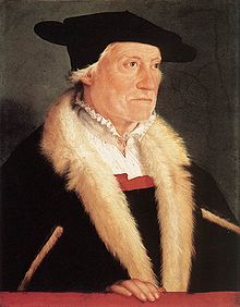
Antique 16th Century Maps by Sebastian Munster

A cartographer who had the widest influence in spreading geographical knowledge throughout Europe in the middle years of the 16th century. His Cosmographia, issued in 1544, contained not only the latest maps and views of well-known cities, but also included an encyclopaedic amount of detail about of detail about the known and unknown world and undoubtedly must have been one of the most widely read books of its time, with nearly forty editions in six languages.


 Münster wrote the Dictionarium Trilingue in Latin, Greek, and Hebrew and Mappa Europae in 1536. In 1537 he published a Hebrew Gospel of Matthew which he had obtained from Spanish Jews he had converted. In 1540 he published a Latin edition of Ptolemy's Geographia with illustrations. The 1550 edition contains cities, portraits, and costumes. These editions, printed in Germany, are the most valued of the Cosmographias.

India by Sebastian Munster circa 1540-1552


See Sebastian Munster's maps here 
Antique maps for sale online