Friday 18 November 2011

Old Maps of Oxfordshire

The county of Oxfordshire and the city of Oxford are well recorded by the map makers of the 18th and 19th century.  Variations in style by the cartographers, engravers and artists enrich the depiction of old maps of old maps of Oxfordshire.

Robert Morden's old map of Oxfordshire was initially produced in the latter part of the 17th century and appeared in a number of subsequent 18th century editions.  It has a pleasing clarity and  a characteristic decorative title cartouche.


Old map of Oxfordshire by Robert Morden circa 1753

Another 100 years on and print making was revolutionised by the introduction of mild steel which replaced the much more expensive copper as a material for engraving.  This is illustrated in the old map of Oxfordshire by Archibald Fullarton.  A much smaller map than that of Robert Morden, iit benefits from the fine lines and detail of steel plate engraving and includes an attractive vignette of the city of Oxford.


19th century old map of Oxfordshire by Archibald Fullarton

Shortly after Fullarton produced his maps, Thomas Moule produced the last decorative atlas depicting the English Counties.  Moule was especially interested on heraldry, and consequently his county maps were decorated with many of the relevant coats of arms relating to each county and their prominent families.  Moule's maps were mainly produced by two engravers, John Dower and W. Schmollenger.


19th century map of Oxfordshire by Moule dated circa 1850

 Thomas Moule's Maps were included in many publication,s including Moule's English County Maps and Barclay's English Dictionary. Not only did these beautiful maps benefit from the introduction of  heraldic elements, the engravers embellished them with highly decorative borders and related topographical vignettes.


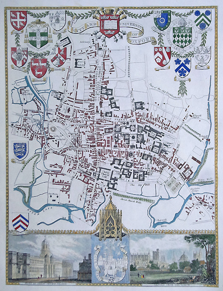
Original 19th century old city map of Oxford by Moule c.1850


Within each publication was also a  selection of antique city maps and old town plans. These plans benefited from even more heraldic content as well as detailed street plans with significant buildings also annotated.  A good example of this is the old map of Oxford by Moule, with no fewer than 15 coats of arms ant two vignettes of Oxford.


See all our antiquarian maps online here

Website design in Devon by Alphawebsites

Looking for affordable gifts for the home? Tealight Wall Holders | Silver Champagne Bucket | Decorative Candle Stands

Thursday 10 March 2011

Thomas Buttersworth Jnr - Marine Painting


Original oil on canvas by Thomas Buttersworth

British Frigate and other boats off the Mediterranean Coast, signed. Fortified tower with a Christian cross, in the background, smaller French ship to left, possibly Algeria? 17.75 x 24 " oil on canvas

Thomas Buttersworth Jnr (5 May 1768 – November 1842)
A seaman during the Napoleonic wars period, became a maritime painter producing works to commission, and was little exhibited during his lifetime. He was born on the Isle of Wight, England. He enlisted in the Royal Navy in London in 1795, and served on HMS Caroline during the wars with France, then was invalided home from Minorca in 1800.

The National Maritime Museum in London has 27 watercolours by him, several of which are mounted on sheets from 18th century, printed signal and muster books.

Other antique marine and maritime oil paintings

Thursday 24 February 2011

Antique Maps of Surrey for Sale


This 18th century map of Surrey by Antonio Zatta is hand coloured and very detailed.

Engraved by Pitteri and drawn by Zuliani it was published in 1779 by Antonio Zatta in Atlante Novissimo.

Full details: Antique map of Surrey by Zatta


Antonio Zatta:

A Venitian cartographer who completed his best known publication Atlante Novissimo by 1785, this comprised of 218 maps including provincial maps of Europe and although he never produced an atlas of British county maps it did include Essex, Kent, Middlesex and Surrey as well as regions of Ireland and Scotland.

He also produced decorative maps after Captain Cook (Austrailia and New Zealand) and a twelve sheet sectional version of Mitchell's large-scale map of the USA, 1755. A characteristic of Zatta's maps are the decorative title cartouches. Also produced Nuovo atlante in 1799. Other cartographers work which he interpreted include Robert de Vaugondy and Bellin.

Other antique maps of Surrey